I completed my MSc research at Dalhousie University in Halifax, Canada as part of the "Marine Environmental Modelling Group" (MEMG) supervised by Dr. Katja Fennel.
The work described below has been published in the academic journal Global Biogeochemical Cycles in two companion papers. It is also included in the third edition of the Dalhousie Oceanography magazine: "Current Tides".
The work described below has been published in the academic journal Global Biogeochemical Cycles in two companion papers. It is also included in the third edition of the Dalhousie Oceanography magazine: "Current Tides".
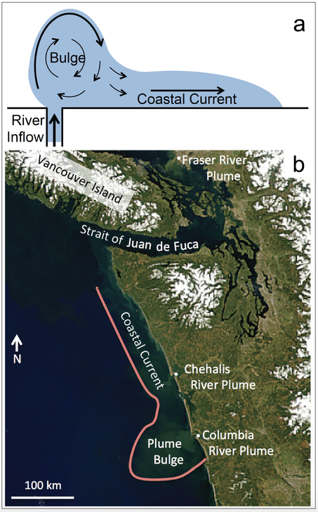
a) Sketch of an idealized river plume deflected by the Coriolis force in the Northern Hemisphere. b) A real river plume (the Columbia River) as seen from space with NASA’s SeaWiFs instrument. The plume, roughly outlined in pink, is visible due to high sediment and chlorophyll loads and extends north all the way to Vancouver Island, Canada.
|
The Importance of Rivers and Nutrients
Rivers carry water across continents, connecting different regions, and transporting materials from one place - mountain springs, majestic lakes, historic cities - to another. In many cases, this another is the ocean, with thousands of rivers delivering 1.2 billion litres of fresh water to the coastal ocean every second. It isn't just water, though. Nutrients (often entering the river as runoff from farmland), toxins (i.e., pollutants), and other suspended particles (such as sediments) are also delivered by rivers to the coastal ocean. Knowing where all of these materials end up is an important factor in understanding the overall health and functioning of the system. |
Where all of this riverine material eventually ends up is strongly determined by the path of water within river plumes. As the fresh water from a river flows into the salty, denser ocean, it remains at the surface and spreads out as a buoyant plume. Due to the Earth’s rotation, the plume is deflected by the Coriolis force (a result of low latitudes moving faster than higher latitudes due to a larger diameter about the Earth’s axis - just like the edges of a record player spin faster than the inside). This apparent force results in the flow turning perpendicular to its motion (to the right in the Northern Hemisphere and to the left in the Southern Hemisphere). This effect is stronger with increasing latitude such that plumes near the equator are barely affected and flow directly away from the coast, whereas plumes at higher latitudes are turned much more. The turning of the plume results in the formation of two distinct regions: a rotating bulge near the mouth, and a coastal current that flows along the shore.
In my research, I used computer models to answer such questions as: What influences the fraction of material transported across the shelf to the open ocean? Can the transport be described simply, knowing only a river’s discharge and location? And, how much total material is transported in river plumes to the open ocean?
Simulating River Plumes with Numerical Models
Some of the most important tools in the Earth sciences today are computer models. In the case of river plumes, however, global models are still too coarse due to current limits in computational power and simply cannot capture the relatively small features of the plumes themselves. As a result, most global models (such as the earth system models used to predict future climate) adopt an all or nothing approach for riverine inputs to the open ocean, assuming everything makes it across the shelf, or that nothing does. Both approaches misrepresent nutrient transport. While models have been successfully developed for individual rivers, to do so for the thousands of rivers on a global scale is obviously not practical. That's where my work comes in.
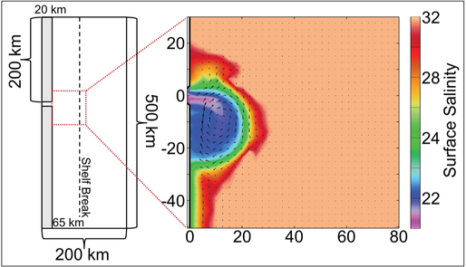
Left: The idealized model domain. Right: surface salinity and circulation in the bulge region of a simulated plume at 45 degrees latitude.
In order to investigate the dynamics of river plumes, I performed a series of numerical simulations under varying conditions. My laboratory, so to speak, was a rectangular coastal ocean set up to represent a simplified river plume system (Figure 3), with fresh water entering through a channel at the coast. Within this setting, I changed the latitude-with different forcing from wind and tides-producing a total of 224 simulations. By individually adjusting the external conditions in the different simulations, I was able to determine the influence of individual factors, which would otherwise be impossible in the real world. To see what a simulation looks like, check out the video page.
From Simulations to Real World Estimates
From the simulations, I was able to develop simple relationships to estimate how much of a river’s material is transported across the shelf within a plume through using only basic properties: the river’s discharge, its latitude, and the local width of the shelf. From the relationships, I calculated the cross-shelf transport for all rivers around the world that flow into the ocean.
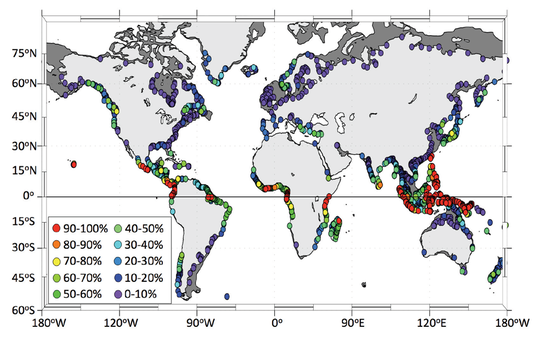
Estimated fresh water export efficiency for rivers around the world. Dark grey is the continental shelf (200 m isobath).
Overall, the most efficient export occurs for rivers at low latitudes and narrow shelves. Near the equator, river plumes flow much further offshore due to the weaker Coriolis force, meaning a higher proportion of material is able to reach the open ocean. At the same time, a narrower shelf (such as along the active subduction zone on the west coast of North America) means the plume has less distance to travel and can still make it to the open ocean, even with stronger deflection. On the other hand, the wide shelves of North America’s east coast mean that export is highly inefficient.
Near the equator, export is very high (in many cases, greater than 90% efficiency), but the deflection due to the Coriolis force results in limited cross-shelf export such that in the mid- to high latitudes, very little material makes it to the open ocean from river plumes. In a global sense, less than 60% of all riverine material that is delivered to the coastal ocean actually makes it across the shelf. As mentioned, this can have serious implications for coastal systems if there are no further processes to dilute the incoming material.
What does it all mean?
The results of my research help work toward a greater understanding of oceanic nutrient cycles, from local to global scales. The simple relationships I developed allow for a quick and easy way of estimating whether nutrients are retained on the shelf, or exported to the open ocean for any river, aiding in the identification of areas at risk of eutrophication and hypoxia. At the same time, the global estimates provide a clearer picture of how and where nutrients are delivered to the open ocean, improving upon the all or nothing approach commonly used. When you consider the sheer volume of material entering the ocean, even a small difference in percentage can have a big impact! Ultimately, these improved estimates can be incorporated into global ocean models (including climate models), allowing for a better representation of the global nutrient cycle.
Further Reading:
- Izett, J. G. and K. Fennel (2018). Estimating the Cross-Shelf Export of Riverine Materials: Part 1. General Relationships from an Idealized Numerical Model. Global Biogeochemical Cycles, 32(2). DOI: 10.1002/2017GB005667.
- Izett, J. G. and K. Fennel (2018). Estimating the Cross-Shelf Export of Riverine Materials, Part 2: Estimates of Global Freshwater and Nutrient Export. Accepted, Global Biogeochemical Cycles, 32(2). DOI: 10.1002/2017GB005668.
- Izett, J. What does a river deliver? Current Tides, Volume 3. [website]
